About sediment yield and precipitation
Mt. St. Helens, a young stratovolcano in south-central Washington, erupted on 18 May 1980
(with some smaller subsequent eruptions). A large amount of loose debris (boulders, gravel, sand and mud) was deposited
into the Toutle River draining Mt. St. Helens in 1980. This debris came from landslides and volcanic mudflows (lahars)
that traveled down the valley floor, and from pyroclastic (airborne) debris that blanketed the upper part of the
Toutle River valley, including the valley walls.
During and after the eruption, material was carried down valley all the way to the Columbia
River, where buildup of debris interfered with ship navigation into Portland, Oregon. The buildup of sediment in
the Toutle River created concern about potential increased flooding during the spring. And there were severe impacts
on the river's ecosystem. The loose material throughout the valley is easily eroded, and can affect the river's
ecosystem for many years following the eruption.
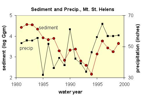
The sediment yield values (measured in millions of kilograms) vary by several orders of magnitude;
such data would be difficult to interpret and see on a single graph. Therefore, logarithms of the sediment yield
are calculated and plotted. The data show a non-linear, almost monotonic decrease of sediment yield as a function
of time, up until about 1994. Students can model this time period with an exponential model of the original or
"unlogged" data, or can use algebra to find the exponential model for the "logged" sediment
yields. An exponential model fits the data fairly well, however tends to underestimate the enormous sediment yields
immediately following the eruption.
Students can use this model to predict sediment yields for 1995 on; the model fails as a
predictor. Sediment yield was rejuvenated starting in 1995; the cause of this increase is clear when precipitation
is compared with sediment yield. High precipitation means more erosion and transport of sediment. Note also the
spike of sediment flux associated with the 1990 wet year.
In 1988, the Army Corps of Engineers built a sediment retention dam upstream from the data
measuring point, to block sediment from reaching the lower part of the Toutle River valley. Did the construction
of this dam affect the sediment yields downstream? Since 1988, the dam has trapped about 80,000 Ggrams of sediment
of suspended sediment.
It would be interesting to use the sediment yield and precipitation values to create a series
of best and worst case scenarios, to determine when the dam will be completely filled with sediment.
References:
Major JJ and others (2000), Sediment yield following severe volcanic disturbance--a two decade perspective from
Mount St. Helens; Geology, v. 28, # 9, pp. 819-822. Data available from http://www.geosociety.org/pubs/ft2000.htm
Precipitation data from the Historic Climate Data Center at NOAA,
see http://lwf.ncdc.noaa.gov/oa/ncdc.html